Topic: Assessing the Impacts of Climate Change on Land Use in El Alto, Bolivia
Research Partner: Stockholm Environment Institute (Somerville, MA)
Sponsor: Lincoln Institute of Land Policy
Project Duration: 2010-2012
(The Lincoln Institute for Land Policy released the final working paper in July 2013. Click here to read the report)
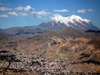
A warming climate is leading to the disappearance of glacial ice in the Andes, with severe implications for communities living in high elevations. The situation is most dire in the sister cities El Alto/La Paz, Bolivia. The historical city of La Paz lies draped over several hundred meters of elevation change in the relatively steep Rio La Paz Canyon. Over time, La Paz expanded upslope and spilled onto the plains of El Alto. At the same time, glacial ice melt, the main source of water for the region’s 1.6 million residents, is permanently melting away. From 1972 to 2004, the coverage of El Alto/La Paz watershed’s glacial area fell from 24% to 3%. Due to the poverty level in El Alto, substantial volumes of water are consumed for peri-urban agriculture, further stressing the system. Water managers for the burgeoning urban agglomeration therefore face enormous pressures inproviding water and sanitation services to all without compromising productive livelihoods or the integrity of aquatic ecosystems.
This study proposes to research the impact of declining water availability on urbanization patterns in high-altitude communities. Using a WEAP hydrological model developed by SEI for El Alto, Bolivia, one of the cities most vulnerable to warming temperatures, this study will develop linked water allocation and land use scenarios. It will examine how projected declining water availability will affect rural-urban migration, drive urbanization in El Alto, impact existing inequalities in water access, and affect watershed protection requirements. Based on scenario outcomes, the study will provide recommendations on how findings from hydrological models can be integrated into land use planning and urban management.
Photo courtesy of Twiga269/Flickr
